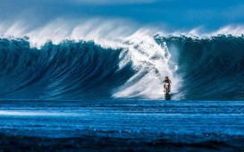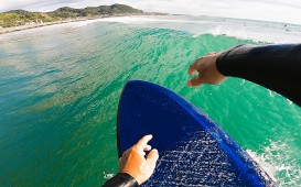
Howzit Howzit…元気?暖かくなってきて本当に嬉しいね!僕は、これからサーフィンモードに突入するんだ。この冬はあまり海に入らなかったけれど、その分スノーボードを楽しんだよ。それと、「ひまわり8号・9号」について勉強していたんだ。
「ひまわり8号・9号」は、日本の気象庁が運用する2つの静止衛星のこと。三菱電機がアメリカのボーイング社の協力で開発したものなんだ。
「ひまわり8号」は、2015年の7月7日から運用が開始され、「ひまわり9号」は2022年には運用が開始されることになっている。(現在は待機運用)
これらの衛星は、三菱電機の研究所がある鎌倉市大船で作られ、打ち上げのために種子島宇宙センターへと輸送されたんだ。(2014年10月7日のこと)
そして、この衛星は今でも大船の施設で運用されているんだ。
何がひまわりを特別なものにしたのか?
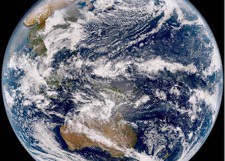
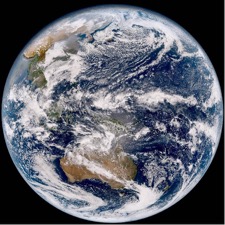
それは、地球のフルカラー写真を10分おきに更新してくれることだったんだ。
赤道上空36,000キロメートルからの気象状況を最小500平方メートル単位で観測することができる前例にない高解像度だったんだ。
科学者たちは、これらの写真によって、生成~進化~終わりまでの大きなスケールでの天気のパターンをさらに理解できるようになったんだ。
リアルタイムで配信されている地球の写真は、10分おきの更新だけれど、日本(解像度1km)のように2.5分おきに更新される特別な場所もあるんだ。
理研AICS(計算科学研究機構)とその共同研究者たちは、降水予想と台風などの急発達する大規模な大気の予報を改善するために、10分おきに更新されるひまわりからの衛星画像のデータを日本の「京コンピュータ」に落とし込んでいるけれど、そのデータは、大気観測と様々な予想モデルを作ることにとても役に立っているんだ。
さらに進んだ撮影では、火山灰による粒子汚染や、植物の健康状態から、そして気まぐれな嵐などを、16の波長帯でフルカラーで撮影して送られてくるんだ。いくつかの例を挙げると、中国から来る黄砂や洪水、積乱雲による突風、火山の噴火活動、風のベクトル解析などに利用されているんだ。
では、波を予想することに関してはどうだろうか?
これらの画像データによって、良い初期値のデータ同化とインプットができるようになるんだ。(予想の精度が向上する)
10分おきよりもさらに早いリアルタイムのデータを得ることもできるようになるんだ。
台風はどこに位置しているのかを10分おきに見ることができるようにもなるんだ。(現在は1時間おきの台風情報となっているから)
今よりもより正確にオンショアからオフショアに変わる時間がわかるようになる・・・など全てのサーファーにとってとても重要な情報になるんだ。
最後に、「地球平面協会」という組織により地球は球体ではないと信じ込まされている人々がいると最近のニュースで報じられていたよ。この団体は、ソーシャルメディアでも、その思想を広く伝えようとしているんだ。信じる信じないは、それぞれの考えだけれど、もっと生産性のあるものに時間を使うことが現実的だと僕は思うんだ。
「地球は平面なの?」
その答えは当然ノーだよ!
第一にひまわりの衛星画像が地球は丸いということを明らかにしているからね。実際に水平線を見てもわかることだよね。
僕らは何に対しても反証することができるけれど、最終的に何が得られる?僕は科学を信じるけれど、陰謀じみた権力みたいなものには疑問を持ってしまうな。
そんなことよりも外へ出掛けたりサーフィンに行くべきだよ。時間は限られているからね・・・。もちろん近所のサーフショップやマリンショップのサポートも忘れずにね。それではまた!A Hui Hou, Malama Pono!
NICTひまわり8号 http://himawari8.nict.go.jp/
以下原文
『Is the world flat?』
Howzit Howzit…I am really glad that it is getting warmer. This winter I didn’t go into the water much but I had a really good time snowboarding. Now it is time to get into water mode. During this past winter I learned about Himawari 8 & 9. Himawari 8 & 9 are two geostationary weather satellites operated by the Japan Metological Agency. These satellites were built by Mitsubishi Electric with help from Boeing. The Himawari 8 started service on July 7th 2015 and it will be succeeded by Himawari 9 in 2022 (it is the backup for now). These satellites were built in Ofuna then shipped to Tanegashima Space Center for launch (October 7th 2014). The satellite is currently managed by the facility in Ofuna.
What makes the Himawari special is that it is capable of taking ful-color photos of the entire planet, every ten minutes. Giving us an unprecedentedly high resolution that can visualize features as small as 500 square meters. These images will help scientists better understand the genesis, evolution, and outcome of large-scale weather patterns. real-time streaming view of the earth (10 min intervals). There are special areas such as Japan (1km resolution) that are updated every 2.5 minutes.
RIKEN AICS (Advanced Institute for Computational Science) and collaborators have used the power of Japan’s K computer to assimilate Himawari satellite data at frequent intervals (10min) into weather prediction models to improve the rainfall predictions and rapid development of large weather systems such as typhoons.
Himawari data helps atmospheric observation and modeling in many aspects. It has an advanced imager, with sixteen wavelength bands to capture everything from volcanic ash to particle pollutants; from vegetation health to full color freak storms. This will allow monitoring of the Yellow sand from China, flood and sudden downbursts of rain, volcanic monitoring, wind vector observation just to name a few.
Now what does this mean for wave prediction? I will allow for better data assimilation of initial and forcing input. Also it will allow for quicker realtime data…10 min, so you will know where the typhoon is every 10 min (right now it is 1hr typhoon reporting). Also it may even allow you to know when the wind changes from onshore to offshore…and all surfers know what that means.
Finally, recently there have been news showing that there are still people who believe the world is flat such as promoted by the Flat Earth Society for one. The popularity of social media has strengthened the claims by these group. Look up the info if you want to but in reality you can use your time for more productive tasks.
Is the world flat? NO! Firstly the images from the Himawari show that the world is round. You can do your own tests on what you see in the actual sky and what is shown on the images. Secondly, we can go around disproving anything and what will we get in the end….wasted time. I say believe science and question authority. Also, with all the time you save by not paying attention to conspiracy theories, the more time you will have to go out and catch good waves!!!
With that, forget about wasting time and get out and catch a wave. Time are hard…don’t forget to support your local surf/marine shop! A Hui Hou, Malama Pono!